Introduction
United Airlines flight 93 (UA93) was commandeered at 9:28 EDT on September 11, 2001, 46 minutes after it took off from Newark International Airport at 8:42 EDT, 42 minutes late. This article is a spatial analysis of the takeover and final moments using United States Air Force (USAF) radar files and Google Earth.
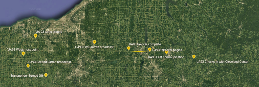
Here is snapshot of key events from the time UA93 entered Cleveland En Route Traffic Control Center (Cleveland Center) airspace until the UA93 transponder was turned off at 9:40:28 EDT.

Turned Back to Target
UA93 Commandeered
UA93 was commandeered in the skies over Warren, OH in just 90 seconds. The attackers waited until the assigned crew checked in with Cleveland Center at 9:25 EDT, and just one minute after the last crew broadcast to the Center.
The commandeer time frame is depicted as the solid yellow line that begins 5 Nautical Miles (NM) east of Warren and ends 6 NM to the west of the city. Air traffic controllers had noticed an unexplained altitude drop. The parameters of that drop are established in USAF radar files from the 84th Radar Evaluation Squadron (84th RADES) as provided to both the National Traffic Safety Board and the 9/11 Commission. Those files were provided to me by the National Archives and Record Administration.
UA93 was flying at 35K altitude. At 9:28:08 EDT it began to drop a total of over 600 feet. It returned to 35K altitude at 9:29:39 EDT. The radar data establishes a takeover that lasted just 91 seconds. It is reasonable to assume that the takeover of the other three aircraft commandeered that day was just as efficient.
The assigned crew was able to make two brief transmissions over the air during the takeover. Immediately, the crew broadcast “MayDay.” That was followed 35 seconds later by “Hey get out of here…” Given that, it then took the attackers less than one minute to gain positive control of the cockpit.
Cleveland Center, Lorrain Radar Position
Commission File 148-911-03007907R-S1
Cleveland Center, Lorrain Radar Position
Commission File 148-911-03007907R-s1
Turn Back to Target
Ziad Jarrah then turned the plane around, unable to maintain constant altitude. UA93 reached nearly 41K altitude during the maneuver. Once flying straight again Jarrah turned off the UA93 transponder, 30 NM west of Akron, OH.
This presented a different case to air defense and air traffic than the earlier situation with American Airlines (AA11). In that case the USAF radars supporting Boston Center were able to determine altitude for a non-transponding aircraft, had they been able to locate the flight. That was not the case with UA93. Older generation USAF radars did not have a height finding capability for a radar only target. It didn’t matter, the air defense controllers at the Northeast Air Defense Sector (NEADS) were unaware of the developing UA93 situation.
USAF radars did track UA93 for a while and then lost it South of Youngstown, OH, and 34 NM WNW of Pittsburgh, PA. One radar, The Plains, did regain coverage briefly just before impact when the transponder briefly came back on.
Here is the 84th RADES forensic analysis of the radar data concerning UA93.

Commission File RDoD04021435
The track is a fine red line running through key data points. Green squares are reinforced returns, that is a return based on both radar and transponder. Red circles are returns based on the transponder only. Purple triangles are either radar only returns or simply atmospheric clutter. Forensically, 84th RADES technicians were able to match up those radar returns that correlated to UA93. The straight red line lower right is the correlation to the final moments of flight UA93.
UA93 Final Moments
Here is the continued 84th RADES forensic analysis of the final path of UA93 to impact.

Commission File RD0D04021435
This analysis is a unique, never published, visual picture of the moments after UA93 quit flying and plummeted to earth. The long, straight red line is a typical 84th RADES correlation of data. It is the result of a fore and aft search to establish a track on an unknown target. The 84th RADES technicians were able to correlate four radar only returns to UA93. Those returns were less than a minute before the transponder came back on. Hence, the moment UA93 quite flying is the red line right angle turn south. That moment was 10:01:57 EDT, just over a minute before impact shortly after 10:03 EDT.
After 10:01:57 EDT, the plane was in free fall, not flying, and falling a bit like a leaf to earth. There is more insight, another primary source of information, the cockpit voice recorder.
Cockpit Voice Recorder, Correlated
Just three of eight black boxes survived the attack of 9/11, the Cockpit Voice Recorder (CVR) from UA93 and the Flight Data Recorders from American Airlines flight 77 (AA77) and UA 93.
Here are selected transcriptions from the UA93 CVR:
10:01:09 Yes put it in and pull it down
10:02:19 Down down
10:02:23 Pull it down
10:03:09 God is the greatest
The “put it in” decision was made about 45 seconds before radar forensic analysis shows UA93 went into free fall. At the time, UA93 was approximately over Latrobe, PA, 26 miles NE of the crash site. The next two cited statements occurred during free fall. In other words, continue the “put it in” decision.
The last CVR statement, “God is the Greatest”, occurred just before the end of the recording at 10:03:11 EDT, an estimate of the impact time. An extrapolation of the radar files suggests an impact time of approximately 10:03:06, close agreement.
Flight Data Recorder, Correlated
The UA93 Flight Data Recorder (FDR) readout is consistent with both the radar forensic analysis and the cockpit voice recorder. UA93 impacted shortly after 10:03 EDT, according to all metrics captured by the FDR.
The linked document is from the Commission Staff Files, Team 7 Box 3. The annotation pinpointing the “hijack” at 9:29 EDT is my hand writing. Metrics displayed show consistent problems after 10:00 EDT. Also noteworthy, Jarrah was not able to maintain straight and level flight after the turn and was in a continuous descent.
Other Confirmations
Gofer 06. Gofer 06 was the unarmed C130, H model, that earlier reported the impact of AA77 into the Pentagon. Thereafter, Gofer 06 continued North, en route home. The flight path was approaching the last known flight path of UA93. As a result, this exchange with Cleveland Center occurred at 10:06 EDT:
Cleveland: Gofer 06, we’ve lost the target on him [UA93], to be safe I’m gonna run you North about 25 miles and then put you back on course…
Gofer 06: OK, Gofer 06, copy, and sir if you’d like we’ve got black smoke at our nine o’clock, looks like about 30 miles.
Commission file 148-911-03007907AA-s1
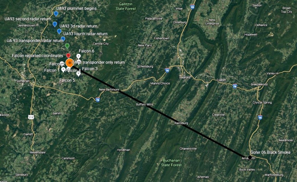
Gofer 06, had been turned North at 10:04 EDT to avoid the projected path of UA93. He soon sighted the black smoke after turn. He was 34 NM SE of the crash site, just south of I70, NW of Hagerstown, MD. At 10:12 EDT, after a turn back West on course, Gofer 06 was due East of the crash site as a private jet was reporting the coordinates to Cleveland Center.
Falcon Jet
Cleveland Center vectored a private jet, a Dassault Falcon 20 owned by VF Corporation, to circle the crash site and provide coordinates.
USAF Radar files show that the Falcon was in a descent from 23K altitude at 10:02 EDT and circled the cite between 10:11-10:15 EDT at 6000-6500 feet elevation. The maneuver was counter-clockwise. Approach was on the south side with a circle around the north side and recovery again on the south side. The coordinates were obtained on the first pass.
Of note, The Plains radar had just intermittent coverage, 6 transponder only returns during the circling of the site. That is typical coverage when an aircraft is in a turn. Here is a close-in snap shot of the event.

Dassault Falcon 20
The UA93 Monument is clearly visible, upper middle. In military terms, data points Falcon 1, 2, and 3 represent the approach pass. Data points Falcon 3 and 4 are the circling pass. Data points Falcon 4, 5 and 6 are the exit pass. Falcon 20 passed the coordinates to Cleveland Center while immediately south of the crash site; 4002.2N 7854.7W. The reporting time was 10:10:14 EDT, just after the radar return designated “Falcon 2.” The Falcon actually reported its own position as is clear from the graphic.
Commission file 148-911-03007907CC-s1
A Combined Picture
Here is a Google Earth screen print showing the spatial relationship of UA93, the Falcon 20 jet, and Gofer 06. Included for reference is a geographic overlay.

Commission files 148-911-03007907Z-s1 and RD0D04021435
Conclusion
Evidence presented here is comprehensive and conclusive that UA93 crashed shortly after 10:03 EDT. Nothing ever aligned for the crew that commandeered the flight. The flight was way late in taking off, the crew was short a person, and air defense was in position by 10:00 EDT, over the National Capital Region. None of that mattered. The remaining crew and passengers had gained situational awareness and too matters into their own hands.
There is one final primary data source to consider. Infrared sensors in space recorded the impacts of all four commandeered aircraft on the morning of 9/11.
Here is the data for UA93: Impact time was 10:03:10+/- EDT. Peak intensity was 10:03:16 EDT. Fireball dissipation was 10:03:25 EDT.
For all impacts, therefore, the fireball was visible for about 25 seconds. Thereafter, black smoke was visible. I can confirm that. I was eyewitness to the immediate aftermath of AA77 slicing into the Pentagon. My office window overlooked the south side of the Pentagon. I went to the widow quickly after hearing the impact and feeling its vibration. All I saw was black smoke.
Interactive Google Earth
Here is a link to Google Earth, a plot that includes both the takeover and the final moments. Click on the projects icon in left vertical menu bar and then click on any data point for detailed information.
